

The E4 long distance trail
The European Long Distance Paths are a network of footpaths that cross European countries. There are a total of 12 such paths and two of them (E4 and E6) run through Greece. The E4 starts in Spain at its southernmost point runs through France, Switzerland, Germany, Austria, Hungary, Romania, Bulgaria, Greece (and Crete) and ends in Cyprus. The total length of the E4 is 10.450 km. The European paths are created by the European Ramblers Association (ERA). In Greece the E4 path is looked after by the Hellenic Federation of Mountaineering and Climbing (their website is www.eooa.gr).
The E4 Hiking Trail in Crete
The E4 European Walking Path in Crete is about 500 km in total, beginning at Kastelli-Kissamos in the west and ending at Kato Zakros in the east. The path takes in some of the most beautiful scenery and interesting hiking country in Crete. It is a hard path with a choice between an alpine section and a coastal section and is for experienced trekkers.
In Crete the path is marked with yellow markers and yellow/black arrows. The whole trek takes about three weeks to complete. The E4 trail in Crete is a hard trekking tour that needs a good preparation!

The E4 Path route is quite varied and can range from simple walking on smooth asphalt roads to some serious hiking in rugged gorges and some real mountain trekking. In parts the E4 trail is very overgrown and difficult to follow. Although there has been lots of new marking in the last years, some sections are still poorly marked. At some points the E4 trail forks into two tracks and you can choose the mountain section or the coastal section.

One such point is in Sougia, a small resort on the south coast, where one route goes along the coast, which is very rough, and one through the mountains. The tracks converge on the south coast near Frangokastello, but immediately branch out again into two sections. A summary of the different sections of the E4 European Long Distance Path in Crete you find below.
Note!! There are many different ways to walk the E4 trail through Crete and the sections shown below are one of the many options. The shown distance can differ at some points and especially the given walking times are an indication! There are some good detailed walking maps which are very useful and also some guidebooks about the E4 which you find below on this page!
Different sections of the E4 trail in Crete
Section 1 Westcoast from Kissamos to Sougia
| Start | End | Length | Time |
|---|---|---|---|
| Kissamos | Sfinari | 22 km | 6 hrs |
| Sfinari | Chrisokalitissa | 31 km | 8 hrs |
| Chrisokalitissa | Paleochora | 14.5 km | 4.5 hrs |
| Paleochora | Sougia | 15 km | 6 hrs |

E4 marking between Elafonissi and Paleochorea
Section 2 From Sougia to Angouseliana the coastal part
| Start | End | Length | Time |
|---|---|---|---|
| Sougia | Agia Roumeli | 20 km | 10 hrs |
| Agia Roumeli | Loutro | 14 km | 5 hrs |
| Loutro | Frankokastello | 19.5 km | 7 hrs |
Section 2 From Sougia to Angouseliana the alpine part
| Start | End | Length | Time |
|---|---|---|---|
| Sougia | Agia Irini | 13.5 km | 5 hrs |
| Agia Irini | Kallergi Refuge | 20.5 km | 5 hrs |
| Kallergi Refuge | Katsivelli Refuge | 18 km | 7.5 hrs |
| Katsevelli Refuge | Askifou | 20 km | 10 hrs |
| Askifou | Frangokastello | 19 km | 6.5 hrs |
Section 3 Frangokastello to Nida plateau (South Branch)
| Start | End | Length | Time |
|---|---|---|---|
| Frangokastello | Argyroupolis | 27 km | 9 hrs |
| Argyroupolis | Agouliana | 23 km | 8 hrs |
| Agouliana | Spili | 13.5 km | 4 hrs |
| Spili | Gerakari | 18.5 km | 8 hrs |
| Gerakari | Fourfouras | 15 km | 5 hrs |
| Fourfouras | Mr Refuge Prinos | 10 km | 4 hrs |
| Mt Refuge Prinos | Nida Plateau | 20 km | 6 hrs |
Section 3 Frangokastello to Nida plateau (Nothern Branch)
| Start | End | Length | Time |
|---|---|---|---|
| Frangokastello | Kato Rodakino | 14 km | 4.5 hrs |
| Kato Rodakino | Agios Konstatinos | 20.5 km | 8 hrs |
| Agios Konstatinos | Armeni | 15 km | 5 hrs |
| Armeni | Arkadi | 29 km | 10 hrs |
| Arkadi | Garazo | 32 km | 11 hrs |
| Garazo | Anogia | 16 km | 5 hrs |
| Anogia | Nida Plateau | 22 km | 6 hrs |
Section 4 Nida plateau to Kato Zakros
| Start | End | Length | Time |
|---|---|---|---|
| Nida plateau | Zaros (through Kamares) | 25 km | 7 hrs |
| Nida plateau | Zaros (through Rouvas Canyon) | 19 km | 5.5 hrs |
| Zaros | Ano Asites | 21.5 km | 9.5 hrs |
| Ano Asites | Ano Archanes | 9 km | 3 hrs |
| Ano Archanes | Kastelli | 28.5 km | 10 hrs |
| Kastelli | Agios Georgios | 20.5 km | 8 hrs |
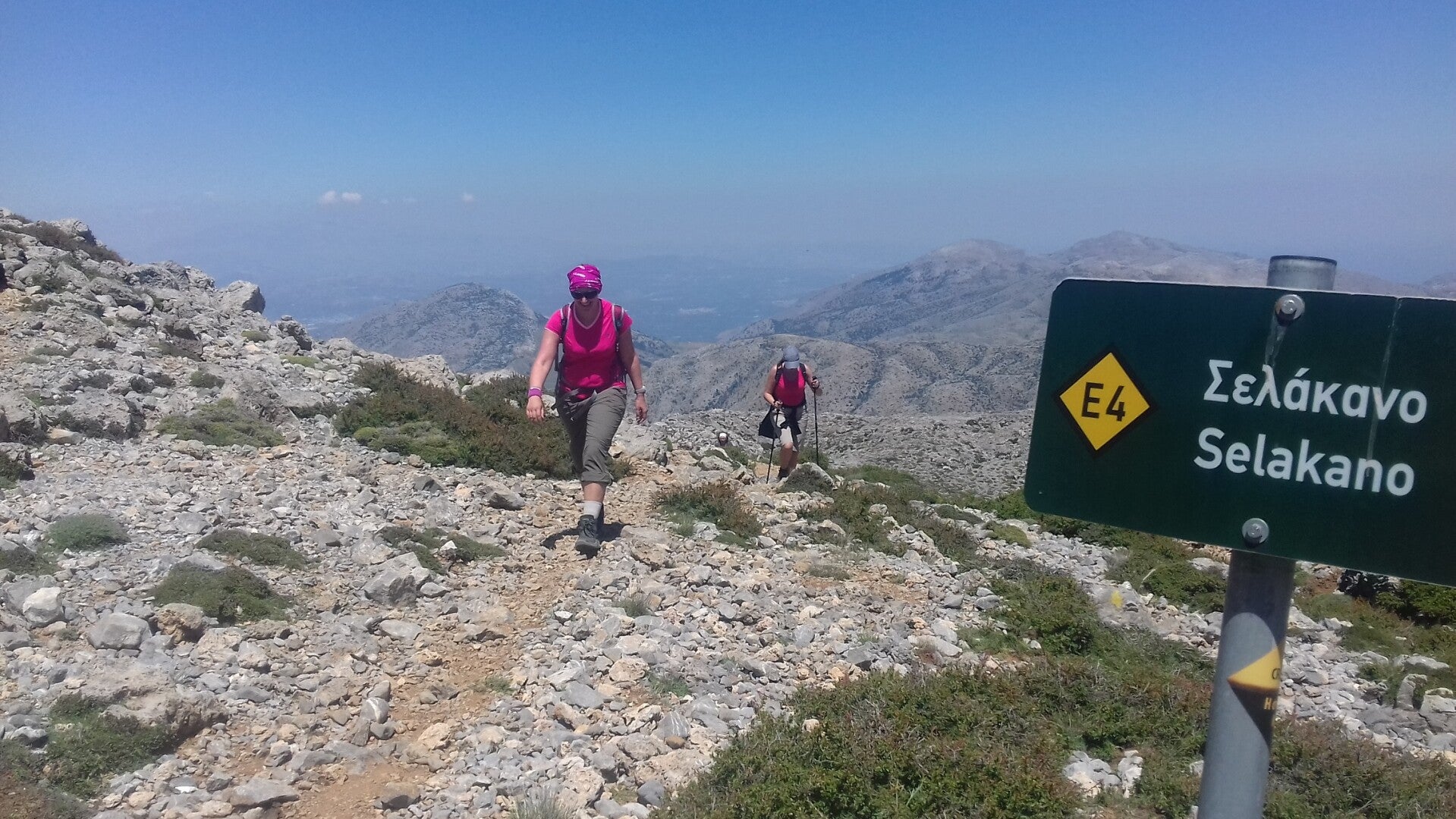
| Agios Georgios | Selakano | 17 km | 6 hrs |
| Selakano | Prina | 18 km | 5 hrs |
| Prina | Vassiliki | 19 km | 6.5 hrs |
| Vassiliki | Ghryssopigi | 18.5 km | 6 hrs |
| Ghryssopigi | Ziros | 17 km | 6 hrs |
| Ziros | Kato Zakros | 16.5 km | 7 hrs |
E4 Books and Maps
Guidebooks E4 Trail
There are two useful guidebooks written about the E4.
From Outdoor (Conrad Stein Verlag) you find a guidebook that describes the E4 parts in the west in the Lefka Ori and the east in the Lassithi area. It is a very useful book and on the website of Conrad you find the GPS-tracks for the described tours! This book is unfortunately only available in German.
Another very useful guidebook is The Cretan Way, written by Luca Gianotti. He describes and follows mainly the E4 from east to west and at some uninteresting parts of the E4 he came up with some new routes. Along the E4 trail you often see signs for the Cretan Way. This book is available in English and Italian.

First published in 2017. Price: € 12,90 - ISBN: 978-3-86686-088-9

First published iby Anavasi in 2016. Price: ca € 16, - ISBN: 978-960-9412-45-2
Walking Maps
Below you find the 5 available walking maps covering a big part of the E4 trail in Crete. They don't cover the whole E4 trail but they cover the mountainous sections! These maps are published by Anavasi and are locally available in Crete in many bookshops.


